yahoo Press
Heat wave, storms to impact millions as tropics are a 'ghost town'
Images
1 / 20
2 / 20

3 / 20

4 / 20

5 / 20
6 / 20

7 / 20

8 / 20

9 / 20

10 / 20

11 / 20

12 / 20

13 / 20

14 / 20

15 / 20

16 / 20

17 / 20

18 / 20
19 / 20

20 / 20
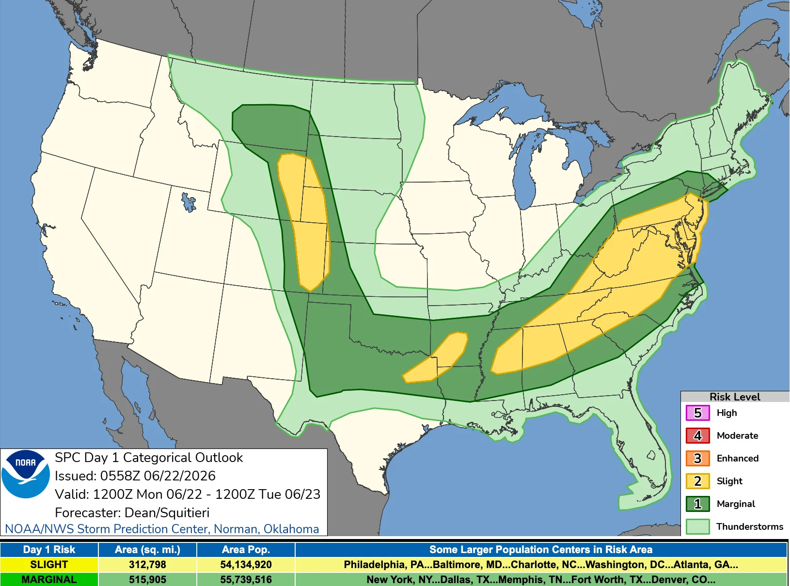
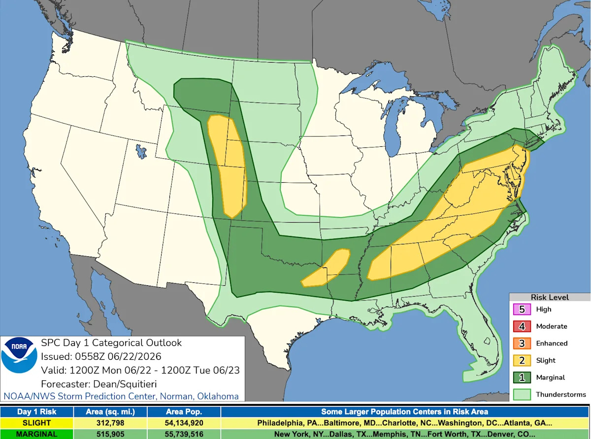
The first few days of summer, which officially began on June 21, will feature extreme heat and potent thunderstorms across large swaths of the country, forecasters said.

This includes a potential severe weather outbreak for June 22 from the Northeast to the High Plains, NOAA's Weather Prediction Center (WPC) said in an online forecast.

Meanwhile, hurricanes are nowhere to be found in the Atlantic basin, which Weather Trader meteorologist Ryan Maue called a "complete ghost town" for the immediate future. However, in the eastern Pacific basin, a pair of tropical disturbances are being watched for possible development in the next several days far from land.

The first full days of summer 2026 will bring above-average temperatures across the western United States, from the West Coast through the Great Basin, Southwest and Rockies, extending eastward into Texas, the Gulf Coast, Southeast and Florida, the WPC said.

The hottest temperatures – over 100 degrees – are expected from west and southwest Texas, into the Southwest and interior California Valleys, while low to mid 90s are expected elsewhere across the above-mentioned regions.

"Heat advisories remain in effect across the Pacific Northwest and Southern Plains, affecting over 21 million people," the WPC said.

In the Pacific Northwest, hot conditions are expected for the Interstate 5 corridor once again, including cities such as Seattle and Portland, where record high temperatures will be in jeopardy on June 22 and 23, according to AccuWeather meteorologist Kai Kerkow.

An active pattern for heavy rainfall and severe weather will continue through the first week of summer as two frontal systems migrate across the central and eastern United States over the next 48 hours, the WPC confirmed.

One particular area of concern for flash flooding was central Arkansas, which could see up to 6 inches of rain. And the threat of scattered heavy rainfall and severe weather will stretch from New York to Wyoming.

"Scattered severe storms appear possible across portions of the Mid-Atlantic into the Southeast, mainly this afternoon and evening," the Storm Prediction Center said in an online forecast. "Widely scattered severe storms are expected across the northern and central High Plains, with more isolated severe weather possible from the southern Plains into the lower Mississippi Valley."

The passage of a cold front will end the threat of organized severe storms and heavy rainfall in the eastern United States by June 23, the WPC said. However, unsettled weather will linger in the central part of the country through midweek with daily chances of scattered flash flooding and severe weather.

In the Atlantic basin, forecasters are predicting a quiet stretch of weather. "El Niño hitting its stride with Saharan dust season peaking means tumbleweeds in the Atlantic to close out the month," said WPLG-TV hurricane specialist Michael Lowry in an e-mail to USA TODAY.

Both El Niño and Saharan dust factors halt tropical storm formation in the Atlantic basin.

According to the National Hurricane Center, for the North Atlantic, Caribbean, and Gulf, "tropical cyclone formation is not expected during the next 7 days."

So far, only short-lived Tropical Storm Arthur has formed in the Atlantic basin. A calmer-than-average season is expected in the Atlantic, thanks to the storm-snuffing affects of El Niño.

However, that isn't the case in the eastern Pacific, which has already seen 3 named storms. This week, a pair of potential systems could develop in the eastern Pacific Ocean, well out to sea. As of June 22, neither system is a threat to land.

Doyle Rice is a national correspondent for USA TODAY, with a focus on weather and climate.

This article originally appeared on USA TODAY: Summer weather forecast includes extreme heat and potent storms