yahoo Press
Severe storms, large hail threaten Charlotte, Upstate SC and mountains, NWS says
Images
1 / 10

2 / 10

3 / 10

4 / 10

5 / 10

6 / 10

7 / 10

8 / 10

9 / 10

10 / 10
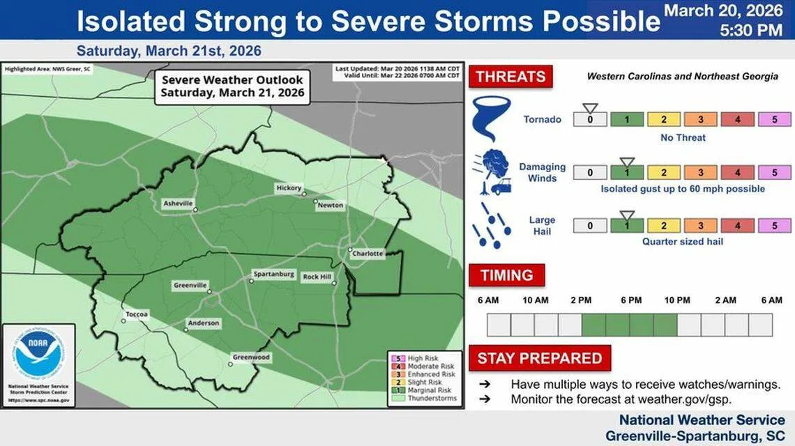
“Strong to severe” storms spread across the Charlotte area, Upstate South Carolina and the mountains on Saturday night, according to the National Weather Service in Greer, S.C.

NWS forecasters issued warnings about 40-50 mph winds and pea- to nickel-sized hail in the Carolina mountains.

Storms descended on the states during a bout of unusually hot temps that could linger into early next week, NWS meteorologists said on social media.

At 4:47 p.m., the NWS warned of 40-mph winds and penny-sized hail for mountain communities south of Biltmore Forest, including Hendersonville, Flat Rock, Tryon and Fletcher.

Minutes earlier, the NWS posted a similar alert for Travelers Rest, Pickens and Easley, S.C.

“A few storms forming over the mountains are moving southeast,” NWS meteorologists said on social media site X at 4:15 p.m. “They are not too tall at this point but there is some lightning showing up.”

At 6:50 p.m., the NWS said 50-mph winds and nickel-sized hail were possible in Anderson, Clemson and Central, S.C. until 7:30 p.m.

“Seek shelter in a sturdy structure,” the NWS posted on X.

Robbinsville, Lake Santeetlah and Fontana Village in Western N.C. faced the threats of 40-mph winds and pea-sized hail until 8:15 p.m., and Shelby, Forest City and Boiling Springs until 9:15 p.m., according to NWS alerts.

A subtropical weather system “will persist over the Desert Southwest and northern Mexico on Sunday and Monday, with steady eastward expansion expected through the period,” forecasters said in a bulletin Saturday morning.

“The result still looks like an extended period of moist subtropical air remaining entrenched across the Carolinas ... and promoting exceptionally warm temperatures each day,” according to the bulletin.

Sunday could reach record highs in the mid- to upper 80s across the region, according to the NWS. Expected highs in the lower 80s on Monday wouldn’t near record warmth but would still be nearly 20 degrees above normal, meteorologists said.

Highs in Charlotte could near 78 on Saturday, 87 on Sunday and 80 on Monday, before dropping to a more seasonal 63 on Tuesday and 65 on Wednesday, the NWS forecast showed.

Highs are then expected to shoot right back up, to near 75 on Thursday and 80 on Friday, according to the NWS.

Monday and Wednesday have a slight chance of showers, the forecast showed.

Rock Hill could see similar highs throughout the week, according to the NWS.